Looking at the extended range data a profound synoptic pattern shift is ready to take hold across the Desert Southwest. A massive mid level anticyclone will retrograde and anchor itself directly over the Four Corners region right after the July 4 holiday. This upper level high will serve as the primary thermal engine to kick off our classic summer convective season and we expect this pattern to hold strong straight through my birthday on July 11.
When diving into the latest runs of the European and GFS models the atmospheric mechanics are coming together with confidence increasing. Evaluating the 700 millibar relative humidity fields alongside wind vectors shows a substantial tongue of tropical moisture advancing northward from the Gulf of California. At the 500 millibar level the geopotential height contours and absolute vorticity signatures reveal distinct shortwave troughs and pockets of spin navigating the southern periphery of that dominant high pressure dome. These subtle ripples of vorticity will supply the essential dynamic lifting required to broadly destabilize the airmass. Furthermore the European model paints an incredibly saturated environment with precipitable water values surging well past the one inch mark across the region.
The physical evolution of these monsoonal thunderstorm complexes follows a rigid topographic rule. Initiation will always target the high terrain first since intense diurnal heating combined with orographic forcing thrusts the unstable air vertically. Once these cells mature over the elevated peaks they unleash dense cold pools and erratic outflow boundaries. These surging density currents then propagate downward steering the heavy precipitation cores off the mountains and into the lower desert valleys during the late afternoon and evening hours. For now this is your classic monsoon setup and w’ere closely monitoring Arizona cities like Flagstaff Tucson Nogales and Phoenix for t-storm risks as well.. The Mogollon Rim and the White Mountains will absolutely serve as the daily ignition zones before the threat descends into the urban metropolitan areas.
Regional Potential Impact Anticipated:
The expanse of this deep moisture transport reaches far beyond the Arizona borders. Over in Southern California the prevailing easterly flow aloft will slam mid level moisture directly into the Peninsular and Transverse mountain ranges. Orographic lifting over peaks like the San Jacinto mountains will detonate isolated intense thunderstorms that can easily roll off the steep grades and trigger abrupt flash flooding down into the adjacent Coachella and Imperial valleys. Moving northward into Nevada the clockwise circulation around the Four Corners high will draw that exact same tropical fetch straight into Clark County. The Spring Mountains towering above Las Vegas will act as the focal point for rapid convective growth. Because the surface boundary layer across the Mojave will be intensely hot and bone dry early in the cycle these high based storms will introduce an extreme risk for severe downbursts capable of lofting massive dust walls and generating destructive straight line winds long before any rain hits the valley floor.
This robust southerly fetch will also pump abundant monsoonal moisture deep into the Great Basin and the Northern Rockies. Utah sits precariously along the western gradient of the upper level ridge where embedded disturbances will spark widespread convective coverage. The high terrain rule remains absolute here as storms will aggressively fire over the Wasatch and Uinta mountain ranges before collapsing into the neighboring valleys. Down in southern Utah the complex network of slot canyons will face a dire flash flood threat as torrential upstream rainfall funnels into those narrow corridors. If the blocking high amplifies enough this moisture axis will penetrate all the way up into Idaho. In that northern domain the primary hazard shifts dramatically to dry thunderstorms. The moisture will pool aloft while the sub cloud layer remains totally parched leading to widespread cloud to ground lightning barrages over the central Idaho mountains that can swiftly ignite volatile wildfires. We will keep watching these mesoscale features closely and provide more refined details on precise impacts as we near the event.
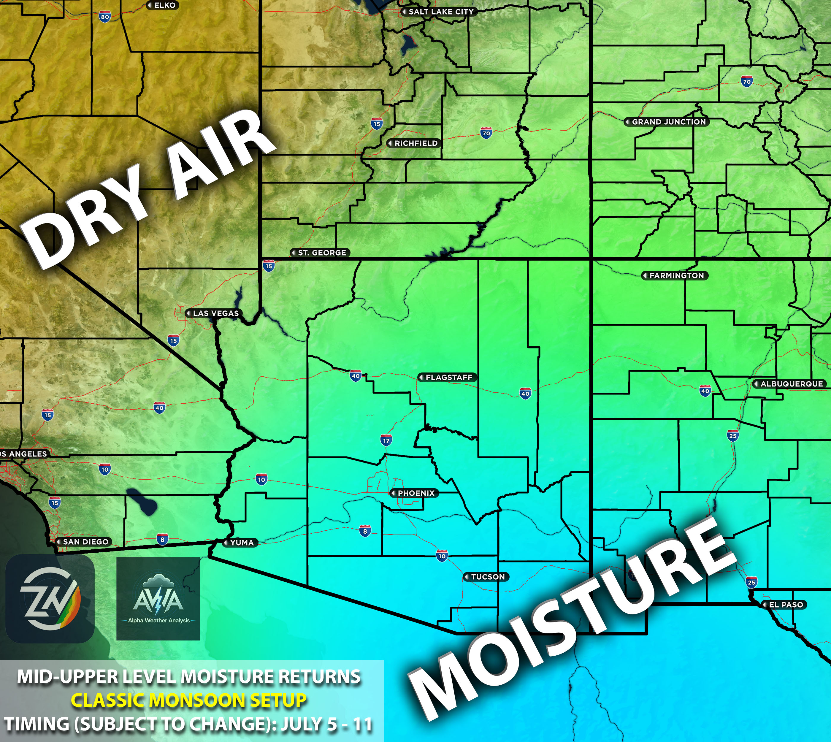
Below, we can already see the model data (in this case, the 700 mb RH and 500 mb relative vorticity) showing the setup coming together, with a clear high-pressure system in the Four Corners funneling mid- to upper-level moisture into the Southwest region.
We can also see the moisture being pulled in looking at the PWA showing further confidence.
While exact timing is still expected to be calculated as well as who exactly gets what, July never less does look to be interesting as we have been saying for a while.
TLDR Version but missing details:
A massive mid level anticyclone will lock over the Four Corners right after July 4 and persist through my birthday on July 11 driving a deep surge of tropical moisture across the Desert Southwest. This classic monsoon setup dictates that intense daytime heating will ignite thunderstorms over the high terrain first before erratic outflow boundaries push these heavy precipitation cores down into the lower desert valleys and urban centers by late afternoon (usual pattern). We will closely monitoring Arizona cities including Flagstaff Tucson Nogales and Phoenix for severe thunderstorm risks along with localized flash flooding and destructive downbursts that can loft massive dust walls. This expansive southerly fetch will also trigger flash flood threats across the steep topography and slot canyons of Southern California Nevada and Utah while pushing volatile dry lightning and wildfire risks far north into the mountains of Idaho.
Stay tuned for more updates.
0 comments