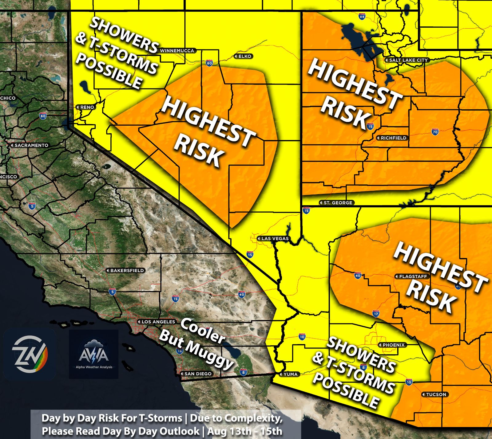
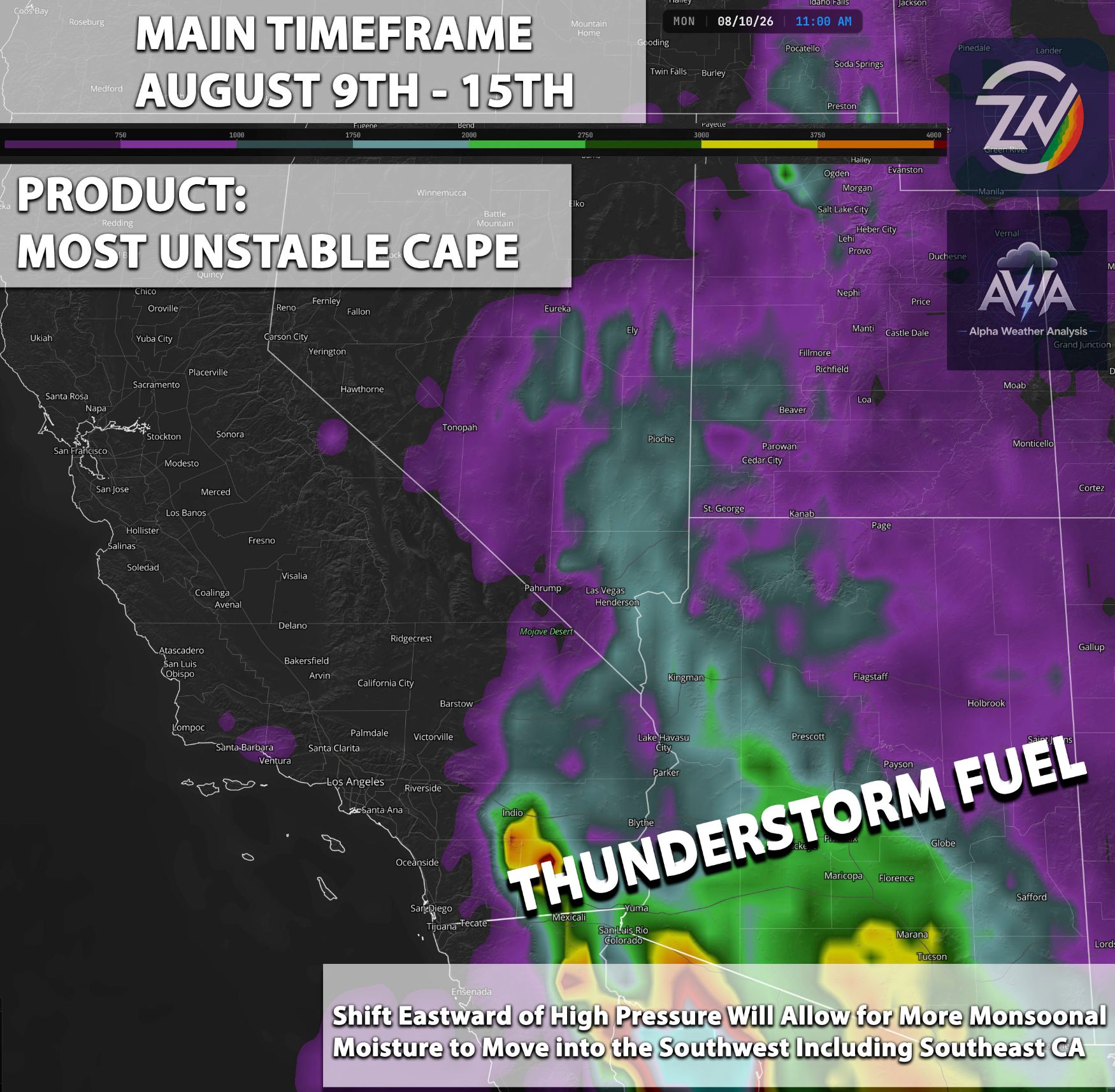
As we’ve stated in previous posts an interesting is expected to finally come around. We have a classic Monsoon setup starting with each day increasing in risk and coverage, starting as soon as tomorrow, with Eastern Arizona starting off somewhat elevated. As we push into the weekend and past it, we finally get that boundary level moisture and shift in flow to bring in that moisture needed combined with other ingredients to produce the classic monsoon t-storms.
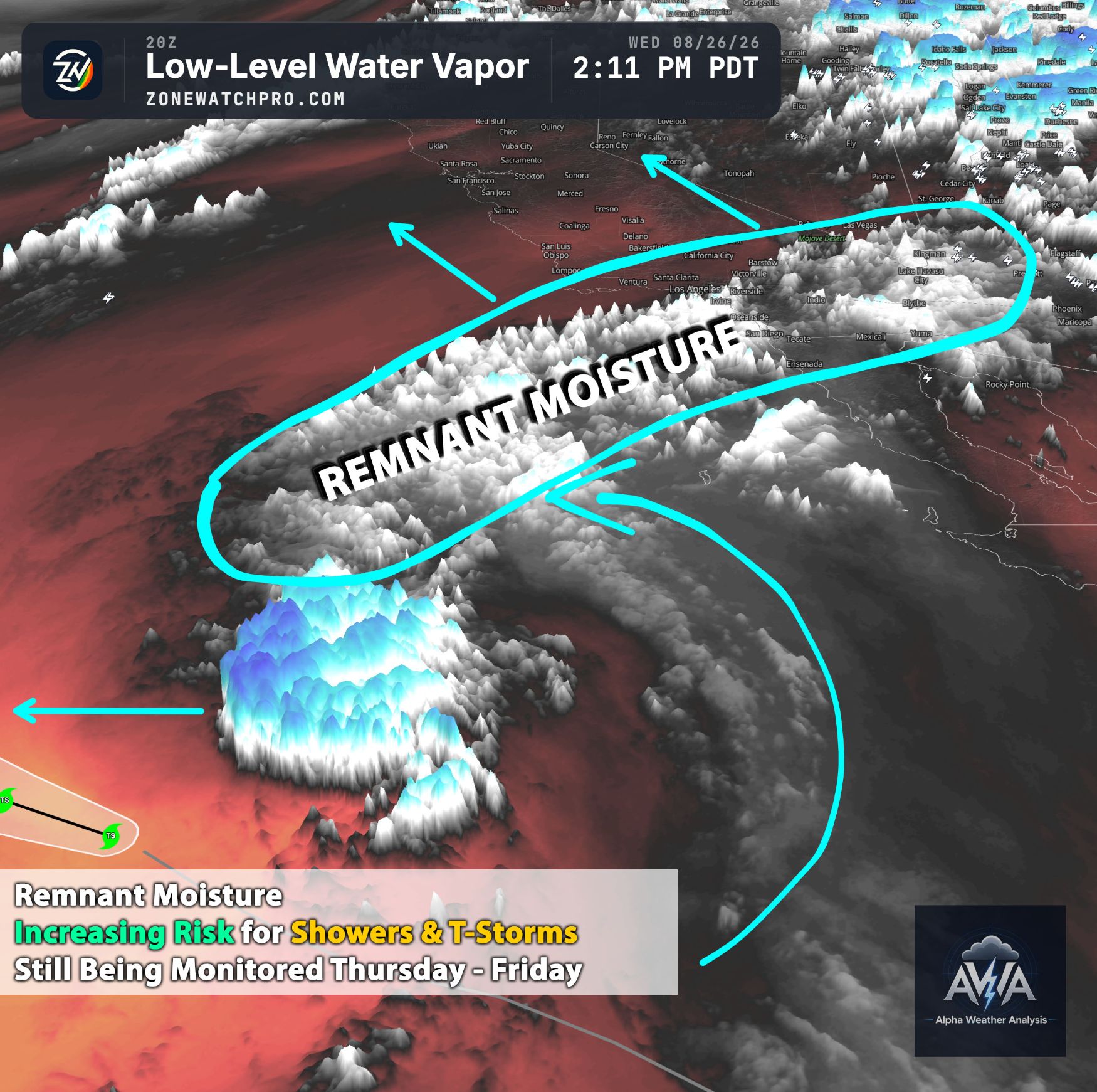
We can clearly observe a robust plume of deep moisture (indicated by the green and blueish colors) surging northwestward from the Gulf of California and the Mexican Plateau. This moisture transport is penetrating deep into Arizona, creeping up the Colorado River Valley into southeastern California, and spreading northward across the Great Basin into Nevada and Utah (surrounding regions).
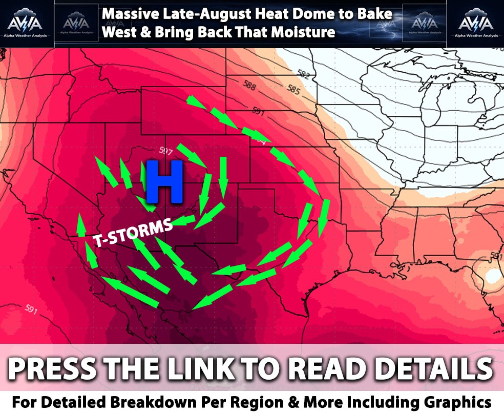
A significant synoptic pattern shift this coming weekend. Model guidance & overall favors the subtropical ridge shifting to the northeast over the weekend, potentially reaching northern Colorado and Wyoming by Sunday. This critical repositioning will shift steering winds to the east-southeast, initiating the advection of deeper subtropical moisture into the region as anticipated. As the upper-level ridge axis migrates northeastward toward the Four Corners, the mid-level flow will sharply veer to the east and southeast, opening the door for a classic Gulf of California moisture surge as well.
Overview & The Marine Boundary Layer for Southern CA The Before Monsoon Flow Pattern (July 7 - 10)
The building upper level ridge will brutally compress the marine boundary layer (MBL) across the coast and coastal valleys from San Diego to Los Angeles, forcing the inversion base to lower significantly below 1,000 feet. AWA Analysis indicates this setup will confine nocturnal low clouds and fog strictly to the immediate coastline, keeping beach communities shielded from extreme heat with highs in the mid 70s to low 80s, though the compressed marine layer will introduce a distinct coastal humidity. Just a few miles inland, rapid clearing will give way to sharp thermal gradients and accelerated daytime heating. Further inland, NBM guidance continues to aggressively push temperatures upward across the Inland Empire as the marine sea breeze struggles to penetrate the valleys, forcing highs to easily breach 100°F and peak between 103°F and 108°F by Wednesday and Thursday. Meanwhile, the deserts including the Coachella Valley and Colorado River Valley will face extreme, dangerous heat as 850mb temperatures approaching 28°C to 30°C translate directly to blistering surface highs of 112°F to 118°F.
The Monsoonal Moisture Surge for Southern CA (July 11 - 15)
The critical pivot occurs this weekend as the upper-level ridge axis migrates northeastward toward the Four Corners, forcing the mid-level flow to sharply veer to the east and southeast and opening the door for a classic Gulf of California moisture surge. ECMWF guidance and recent atmospheric graphics show a robust plume of subtropical moisture overrunning the region by Sunday, July 12th, driving a dramatic spike in Precipitable Water (PWAT) values that will likely exceed 1.50 to 1.75 inches across the lower deserts and push above 1.25 inches west of the mountains. According to AWA Analysis, as intense surface heating destabilizes the boundary layer over the high terrain on Sunday and Monday, orographic lifting will act on this incoming moisture; however, because the sub-cloud layer will initially remain extremely dry, this setup introduces a severe dry lightning and erratic downdraft threat for the San Bernardino, Riverside, and San Diego County mountains. As the atmospheric column fully saturates by Tuesday and Wednesday, this convective threat will rapidly transition to wet microbursts, heavy rainfall, and flash flooding, particularly over recent burn scars and flood-prone areas. While precipitation rarely reaches the immediate coast during these initial surges, the thermodynamic environment will change drastically as dewpoints across the coastal plain and inland valleys surge into the mid-60s, creating muggy, oppressive conditions. Furthermore, steering flow could push potent outflow boundaries from mountain convection westward into the valleys during the late afternoon and evening hours, kicking up blowing dust and localized gusty winds.
The Monsoonal Moisture Surge for Arizona (July 11 - 15)
Arizona after a few days of just mainly high terrain t-storms and more towards the east high terrain area will transition to the well east southeast flow which allows for a favorable fetch of southerly flow and leading to improved boundary layer moisture (meaning not just mid-upper level).
Southeastern Arizona & High Terrain Convective Progression
Southeastern Arizona will act as the primary gateway for the incoming subtropical moisture plume, experiencing the earliest and most widespread convective impacts during this monsoonal transition. AWA Analysis notes that moisture values will steadily increase as the week progresses, driving a daily westward expansion of afternoon and evening showers and thunderstorms that will fully extend into western Pima County by the weekend. This setup creates distinct regional hazards: areas west of Tucson will primarily contend with strong, damaging winds and severe blowing dust driven by high DCAPE values operating within a deeply mixed boundary layer. Conversely, locations from Tucson eastward will face an escalating threat of flash flooding as deeper, precipitable water pools over the rugged terrain. Further north, across the high terrain of Flagstaff and the White Mountains, the atmosphere will undergo a similar battle between lingering dry air and the northward monsoon push. While dangerous, elevated heat persists within the lower elevations of the Grand Canyon for most of the week, monsoonal moisture pooling across southeastern Arizona and western New Mexico will leverage these elevated heat sources to initiate convection. The upper-level ridge is projected to temporarily flatten later in the workweek, briefly suppressing storm development southward, before rebounding robustly by the weekend and into early next week. This subsequent rebound will allow diurnal thunderstorm activity, initially anchored over the White Mountains, to march steadily westward toward Flagstaff, keeping baseline ambient winds outside of localized convective outflows to typical afternoon southwesterly breezes of 10 to 20 mph.
Central & Southwestern Desert Thermodynamic Transition
In contrast to the mountains, the central and southwestern lower deserts including the Phoenix metro, Yuma, and the Lower Colorado River Valley will experience a delayed onset of actual precipitation, initially dealing with the stark thermodynamic byproducts of the shifting high-pressure ridge. The extreme, oppressive heat characterizing the early portion of the week will slightly relent as large-scale subsidence weakens and low-level moisture begins to bleed into the region over the weekend. According to AWA Analysis guidance, significant precipitation and measurable rainfall chances for the lower desert floors are more likely than not to hold off until the late weekend or early next week (where the main flow of moisture comes in). Before any rain drops survive the trip to the surface, the region will experience periods of thick mid- and high-level cloud ceilings. As deep convection fires over the higher terrain to the east, the primary operational hazard for the Phoenix metro will manifest as aggressive, dust-laden outflow boundaries pushing rapidly westward into the dry desert boundary layer. For meteorologists tracking this evolution, utilizing high-resolution mesoscale modeling like the HRRR and NAM 3km will be absolutely critical as the event nears, allowing for the precise identification of these shifting outflow convergence zones to accurately forecast sudden visibility drops, localized habitat destruction, and violent wind shifts.
Plain English Summary:
A major weather shift is expected this weekend as a high-pressure system moves northeast, pulling a massive wave of classic monsoon moisture into the Southwest. In Southern California, early-week extreme inland heat and coastal fog will give way to muggy humidity by the weekend, bringing a severe threat of dry lightning, heavy mountain rain, and potential flash flooding. Meanwhile, Arizona will see thunderstorms start in the eastern mountains and steadily march westward. While the high terrain faces heavy rain and flood risks, lower desert areas like Phoenix will initially battle dangerous heat and massive dust storms triggered by strong winds blowing off the mountain storms, with actual rainfall finally arriving late in the weekend or early next week.