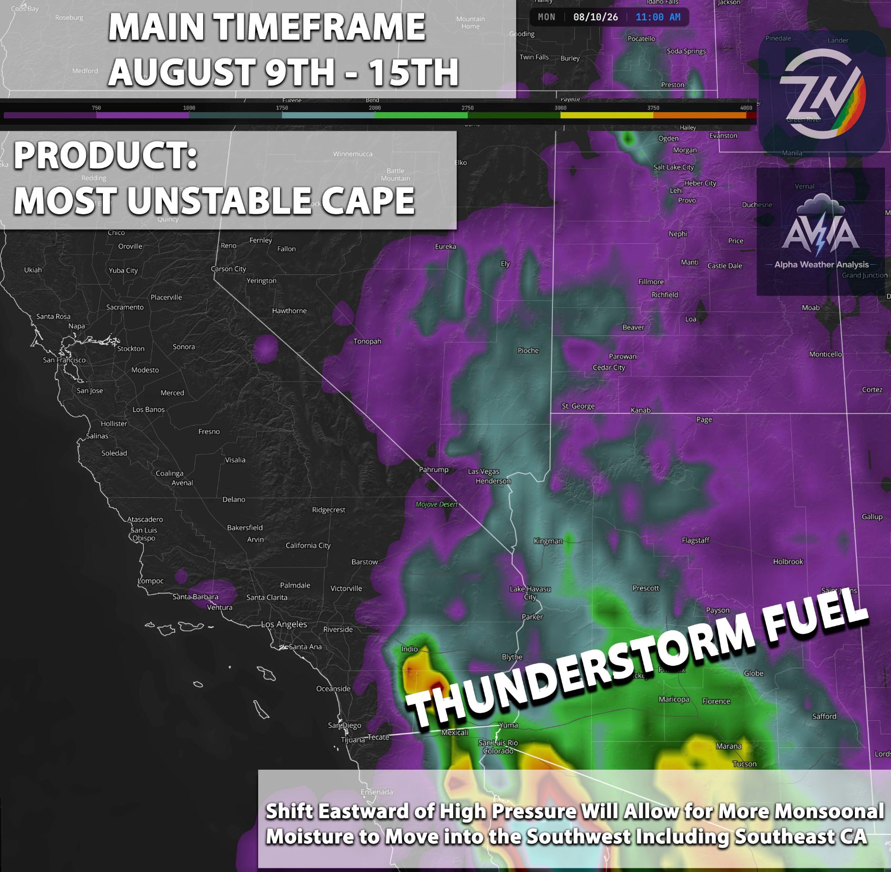
We are starting off with a very hyper monsoon. People across the Arizona region, Nevada, and surrounding states have already seen a significant amount of thunderstorms, with a lot of severe storms embedded as well. Storms were able to produce damaging winds, dust storms, large hail, and very frequent cloud-to-ground lightning. Much more is yet to come as we're just starting off with this hyper activity.
Southern California has yet to get those types of storms. However, as the pattern continues to change, things do look up for that area as well. This monsoonal pattern, especially with the next coming flow, as the high pressure moves closer towards the Southwest, will really focus on bringing in some extreme amounts of flow. This is pulling in more monsoonal moisture, combined with insulating and other ingredients, and will produce more widespread and numerous thunderstorms, with many perhaps becoming severe.
This looks to happen pretty much every single day with the next flow, with some days being more focused while others perhaps just your norm monsoonal days. People across Arizona are already really enjoying all these thunderstorm activities, while others who have plans have been hating it as they would have to keep on canceling or delaying them. Areas that did get hit with damaging storms are still recovering from the damages, and we're just still starting off as this El Niño-driven monsoon just continues to amaze most meteorologists and forecasters across the southwestern region.
At the same time, we have El Niño climbing at an increased pace. We're already , The track for El Niño is expected to continue to grow rapidly, bringing very significant impacts, perhaps to all of the Southwest region, if not the entire globe (as it already has done so). This can already be seen across the entire globe: record temperatures in areas that usually don't get those types of temperatures and extreme hyperactive tropical activity, with back-to-back typhoons across the Pacific Ocean towards the Asian coast as well. For us, our tropical storm and activity is still starting and really, really ramping up day by day, with way more moisture expected to come into the Southwest, and we're not seeing it end this for quite some time. The El Niño portion we will go into detail in the next article. For now, we already have too much to discuss about the upcoming pattern/setup day by day. Let's break it all down detail by detail.
Overall Outlook for Each Regions Covered
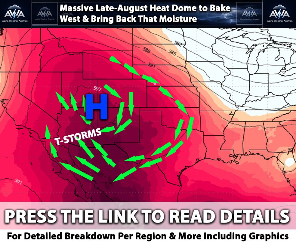
The weather pattern across the Desert Southwest today and tomorrow is being dominated by a massive dome of high pressure anchored near the Four Corners region. Looking at upper-level atmospheric maps (specifically the 500 millibar heights, which measure the altitude of a certain pressure level and indicate where heat is trapped), this high-pressure system is causing sinking air and intense heat across the interior West. However, this ridge is also acting like a giant atmospheric engine perfect for those known monsoon storms but this time a lot more hyperactive given the large amount of moisture and thermodynamics to work with, spinning clockwise and pulling deep monsoonal moisture (a seasonal flow of humid air from the tropics) up from the south and east. Atmospheric moisture shows elevated amounts of moisture in the air and small ripples of energy or areas of spinning air aloft moving through, the stage is set for daily thunderstorms across much of the region.
Arizona & Severe Thunderstorm Threat
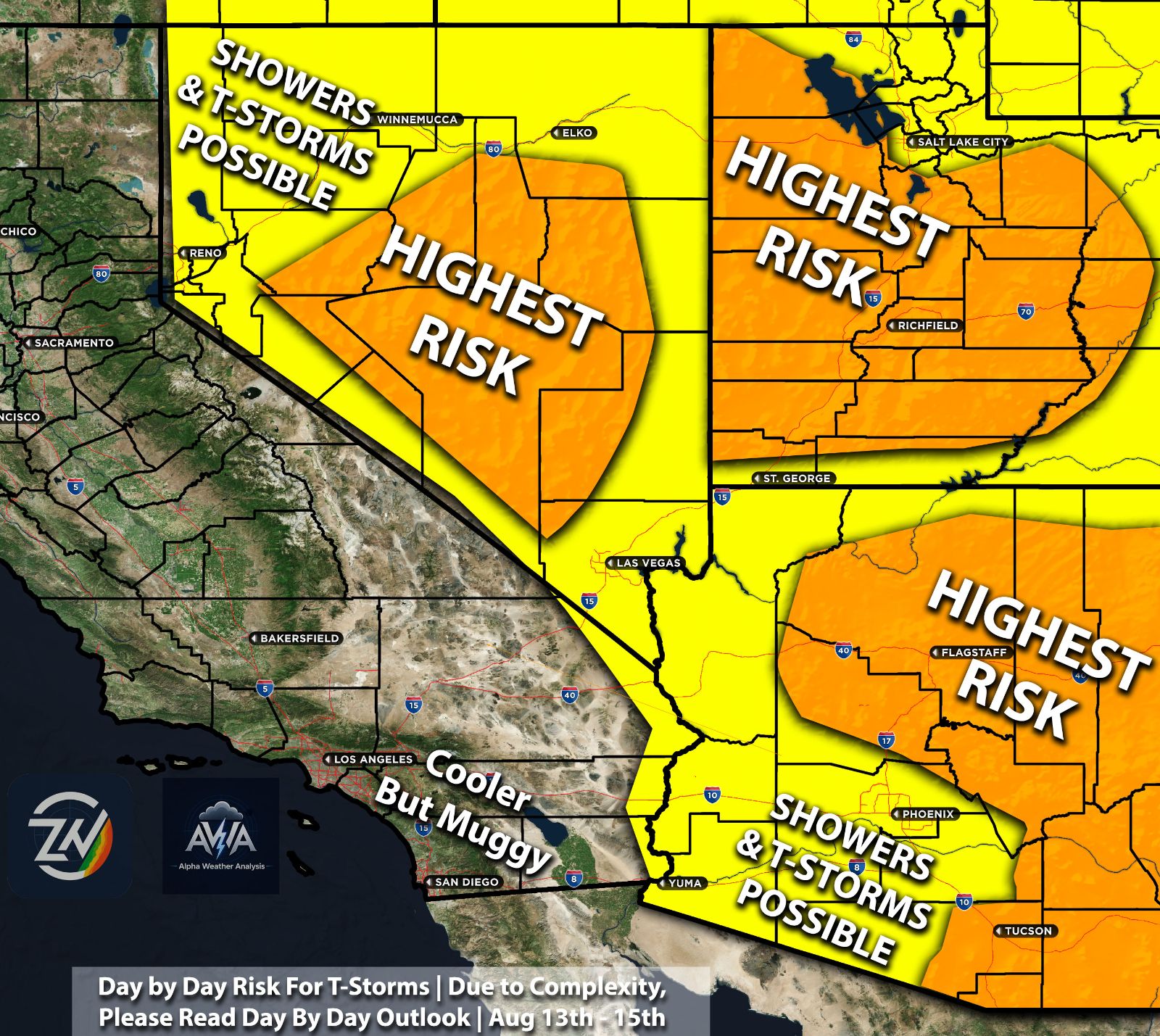
For today and tomorrow, Arizona remains entrenched in an active and dangerous monsoon pattern. The Alpha Weather Analysis Team notes that deep moisture is being pulled across the state, setting off daily rounds of showers and thunderstorms. Today, these storms rely heavily on orographic lift a process where wind hits the mountains and is forced upward, acting as a natural ramp to spark thunderstorms over the higher terrain during the early afternoon. As these mountain storms collapse, they will send out strong outflow winds bringing isolated to scattered storm activity into the lower deserts, including the Phoenix Metro as well.
Today presents another escalated severe thunderstorm risk across Arizona, specifically targeting both the Phoenix and Tucson metropolitan areas included. We continue to monitor and see agreement that a large easterly disturbance will track into the region, pushing precipitable water (moisture) values to exceptional levels. High-resolution computer guidance also indicates a major shift in the upper-level wind flow out of the northeast. This steering current will aggressively push thunderstorm energy and mature, severe storm cells off the White Mountains directly into the lower valleys and major urban corridors. ZoneWatch BETA models also continue to signal an elevated likelihood for severe, damaging outflow wind gusts exceeding 35 to 50 sometimes exceeding 60mph miles per hour across both the Tucson and Phoenix metros, bringing a primary threat of severe weather, localized flash flooding from heavy downpours, and sudden, dense walls of blowing dust.
Nevada
Southern Nevada is also feeling the effects of this moisture surge, with the Alpha Weather Analysis Team pointing out that temperatures will remain near or slightly above normal through midweek. Because the atmosphere here does not currently possess an extreme amount of explosive energy (instability), storm development will heavily favor the high terrain and mountains surrounding the Las Vegas Valley. Once morning cloud debris clears out and the sun heats the ground, this thermal energy will combine with the mountain slopes to trigger afternoon convection (the rapid rising of warm air that builds storm clouds). The main hazards for any storms that develop today and tomorrow will be cloud to ground lightning, brief heavy downpours, and sudden gusty outflow winds. While the Las Vegas Valley itself sees lower probabilities for direct rainfall, those strong outflow winds from distant mountain storms could easily sweep across the city in the late afternoon and evening hours. Should things change, look for another update.
Southern California Slight Elevated Risk Mainly High Terrains
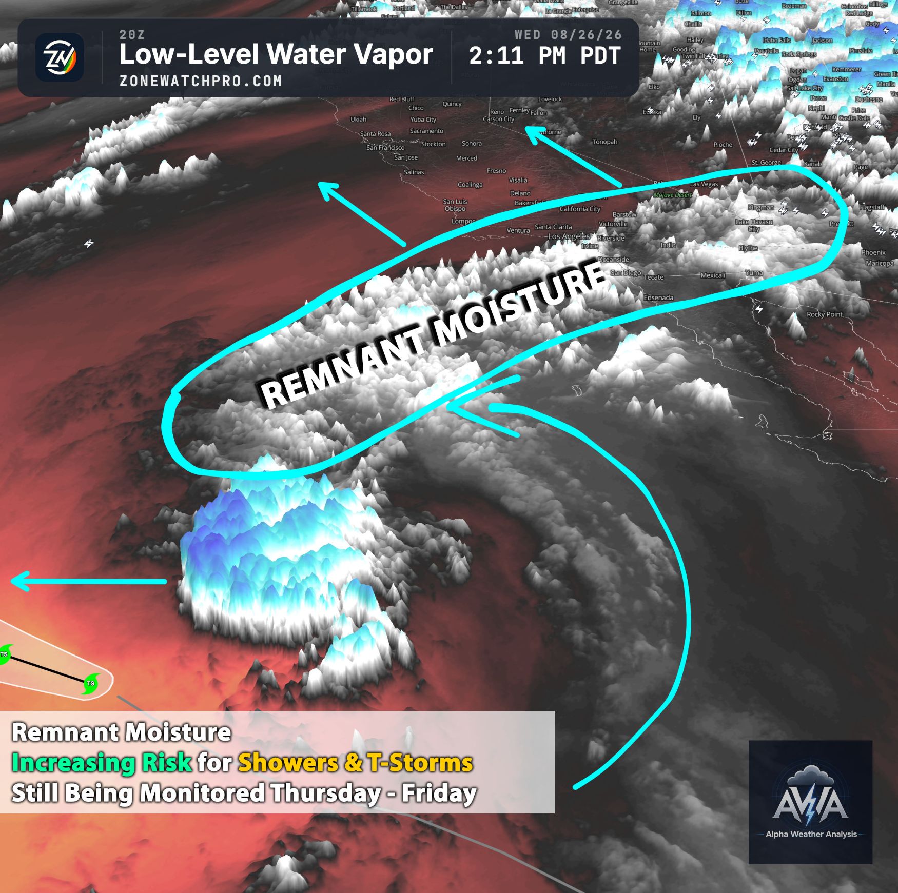
The monsoonal moisture is there but low level dry air also present pushing into Southern California, leading to a clash between the humid tropical air and the region's typical coastal weather with LL dry air. We can see that an influx of moisture is creating an environment somewhat elevated for afternoon and evening thunderstorms not so much on Wednesday but, likely on Thursday, primarily targeting the mountains, and high deserts. We will monitor with alerts and outlooks through AWA and social media on should risk increase more westward, The setup has to do with mid level relative humidity maps show a thick, supportive layer of moisture trapped over the mountain ranges. At the same time, daytime heating is driving a heat wave, for the inland valleys and mountains, with high temperatures expected to peak well above normal. While the coast will stay relatively dry, beachgoers should be aware of a separate hazard… high tides.
Utah
Utah is located closer to the center of the massive high-pressure dome, leading to a prolonged period of hot and dry conditions, with a strengthening ridge into the weekend. However, the high-pressure system is still pulling mid-level moisture up from the south into the state. Because the air near the ground is extremely dry, the rain from any thunderstorms that develop often evaporates before hitting the ground known as virga. This evaporation process cools the air rapidly and causes it to plummet to the surface, creating a serious threat of dry lightning and severe, gusty outflow winds of 40 to 50mph (locally higher). These high-based storms will be scattered across the higher terrain today and tomorrow, presenting an elevated fire weather risk due to the combination of dry fuels, lightning, and erratic winds.
Here we can see the storm fuel also known as Most Unstable CAPE or instability being elevated enough combined with other ingredients (for the southwest region) for t-storms with a few being strong to severe. Stay tuned to ZoneWatch and AWA for more updates as this pattern continues for a long time… we just will not get any quiet periods for a while… good for some (weather geeks) bad for others.